An easy-to-use app on your phone is a great way to discover and plan walking and cycling routes.
We’ve been trying out walking apps from Ordnance Survey, Viewranger, Komoot and more, and here’s what we thought.
Latest update: December 2021
All our reviews at Campfire Magazine are independent and honest.

Which way now? We enjoy getting lost, but a map would be useful now and then!
Why have a walking app rather than a good old map?
We wanted to walk to Brantwood from Hawkshead village on a recent camping trip. The friendly post office owner kindly showed us some possible routes on the Ordnance Survey map.
We love maps and are happy to buy them, but the problem is that, to be detailed enough, they have to cover a fairly small area, and you can soon end up with a house full of maps for places you’ll never go to again.
So, is a map app the answer? A note from Viewranger arrived in our inbox at just the right time, so we decided to check out the options.
Having said that, maps are beautiful works of art when you think about it. Have a look at the huge range on the Ordnance Survey website and maybe an app and map combo is right for you. Many of the OS maps come with a free digital version too.

OUR FAVOURITE
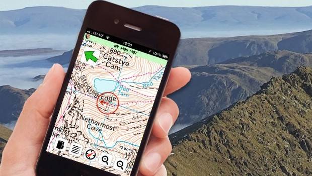
Viewranger is a very highly thought of UK-based app that uses OS, trail guides and other reliable sources and has a professional feel to it. It proved to be so good.
In fact, it’s used by search and rescue teams. You have to buy area maps, and the Lake District, for example, costs around £25. There are worldwide map options too.
The basic app is free, and you can then buy areas or map credit. Lots of functions, works with no phone signal, however, and check out the great skyline feature.
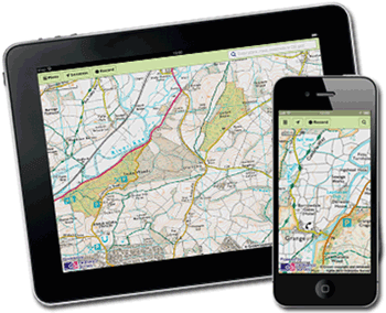
A close contender to Viewranger, the Ordnance Survey has its own OS Maps app with 500,000 routes and alls its maps available on all your devices.
There’s a subscription package for £30 a year or a bit cheaper if you go onto auto-renew. You can also pay £3.99 for a month, which might be useful if you’re going on a short trip and don’t need the app all the time.
Masses of features, including snap-to-path in National Parks. You can synchronise your routes with the desktop version, import and export GPX files to discover new routes, and turn on route following to alert you when you go off your planned path.
Try it for free for seven days.

Komoot is free to download for iOS and Android and comes with one free region. After that, you can buy all regions for £29.99, choose a single region (Cheshire, for example) for £3.99 or go for a £8.99 regional bundle (Bouches du Rhone, for example).
You can plan one-way or circular walks or road and mountain bike tours with details of length, climb and difficulty; find campsites, museums, places to eat and drink, swimming pools and more in any chosen area, get inspiration from other Komoot users and even record your own trips to share. There’s also a social media aspect too, if you choose to use it, so that you can connect with fellow Komooters. Oh, and very importantly, you can save maps and tours for offline use.
it’s a little complicated at first but we soon got the hang of it and tested it out on a fantasy rerun of our Hawkshead to Brantwood hike. The tour screen showed us a route through the woods, mapped places to eat and pinpointed our campsite. We were impressed. Our only niggle was that some regions were oddly categorised or named. South Yorkshire, for example, is a region bundle that also includes West Yorkshire.
Other options
The iOS, Google and Android app stores have lots of more specialised, targeted apps for tracking your walks or rides or for mountain hikes, for instance.
Check the details to see if the functions are what you want, check the in-app purchases to find out what you’re getting for free (and what’s charged for) and have a look at the reviews!
We don’t recommend Alltrails. We found it gobbled up battery and was inconsistent in suggesting trails – some we knew weren’t there and some it suggested were on private land. And Gaia GPS is really only for US hikers and, for goodness sake, for hunters! No thanks.
And here’s a little tip for Google Maps users. Did you know you can save maps for offline use? And create your own?
You might also be interested in our guide to apps for finding campsites and wild camping spots.
